FarmEasy Learning Center
Here you will find answers to frequently asked questions, guidance on how to use the system, video tutorials and user guides.
What help are you looking for?
F.A.Q.
Of course. If you are interested in optimising your operations, improving efficiency and saving resources, contact our team and we will prepare a personalised proposal for you.
“Datavaxt” – is a Swedish company providing advanced precision agriculture solutions including crop planning applications, GPS tracking systems, field drainage solutions and automated management technologies.
We are the only one that is not a start-up, as Datavaxt has been in this market since 1996. FarmEasy also stands out because it covers most of the functionalities in one place (competitors’ solutions are more focused on certain parts).
We provide all the necessary instructions on how to get started with the products and, at the beginning of the integration, we provide system training so that you can learn how to fully operate the Datavaxt platform.
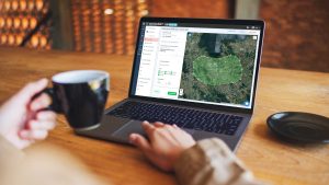
NDVI (Normalised Difference Vegetation Index) is an index compiled from satellite data that shows the amount of plant biomass. It helps to assess the condition of the crop, identify problem areas (e.g. due to lack of moisture, diseases, pests or nutrient deficiencies) and plan targeted agronomic actions such as variable rate nitrogen fertilisation with CropSAT. A higher index value usually indicates a more vigorous, healthier vegetation.
Variable Rate Application (VRA) maps are digital maps used in precision agriculture. They indicate how much fertiliser, seed or crop protection products should be applied/sprayed in different areas of the field, based on soil properties, previous years’ yields, satellite data (e.g. from CropSAT) or other factors. Using VRA maps through CropMAP and compatible techniques, it is possible to optimise resource use by applying more where the potential is highest and less where it is lower, thus saving costs and increasing overall yields and reducing negative environmental impacts.
The satellite passes over Lithuanian fields every 3 days, i.e. once every 3 days. However, to ensure the quality and usability of the satellite images, we take into account weather conditions, such as cloud cover, which means that images may appear less frequently.
No, one account is enough. You can enter as many farms as you want per account in CropPLAN.